![]()
DirtSignal preprint finds public Street View imagery can reveal property neglect months before code-enforcement records appear.
MIAMI, CA, UNITED STATES, June 15, 2026 /EINPresswire.com/ — DirtSignal, a property intelligence platform built on public-record distress signals, has published a preprint measuring how well freely available aerial and street-level imagery predicts residential code-enforcement violations. The study, “Seeing Neglect: Measuring the Predictive Value of Public Aerial and Street-Level Imagery for Property Code Violations,” is available at https://dirtsignal.com/updates/seeing-neglect-property-violation-preprint.
The central finding is one of timing. Using dated code-enforcement records from Jacksonville, Florida, the study found that a Street View image of a property carried a statistically significant signal of a future first citation. This is strongest when the photo was taken within six months of the citation, and still significant up to a year before. A subset of properties were visibly neglected for years before any record existed. In short, the physical condition appears in public imagery months before local government writes it down.
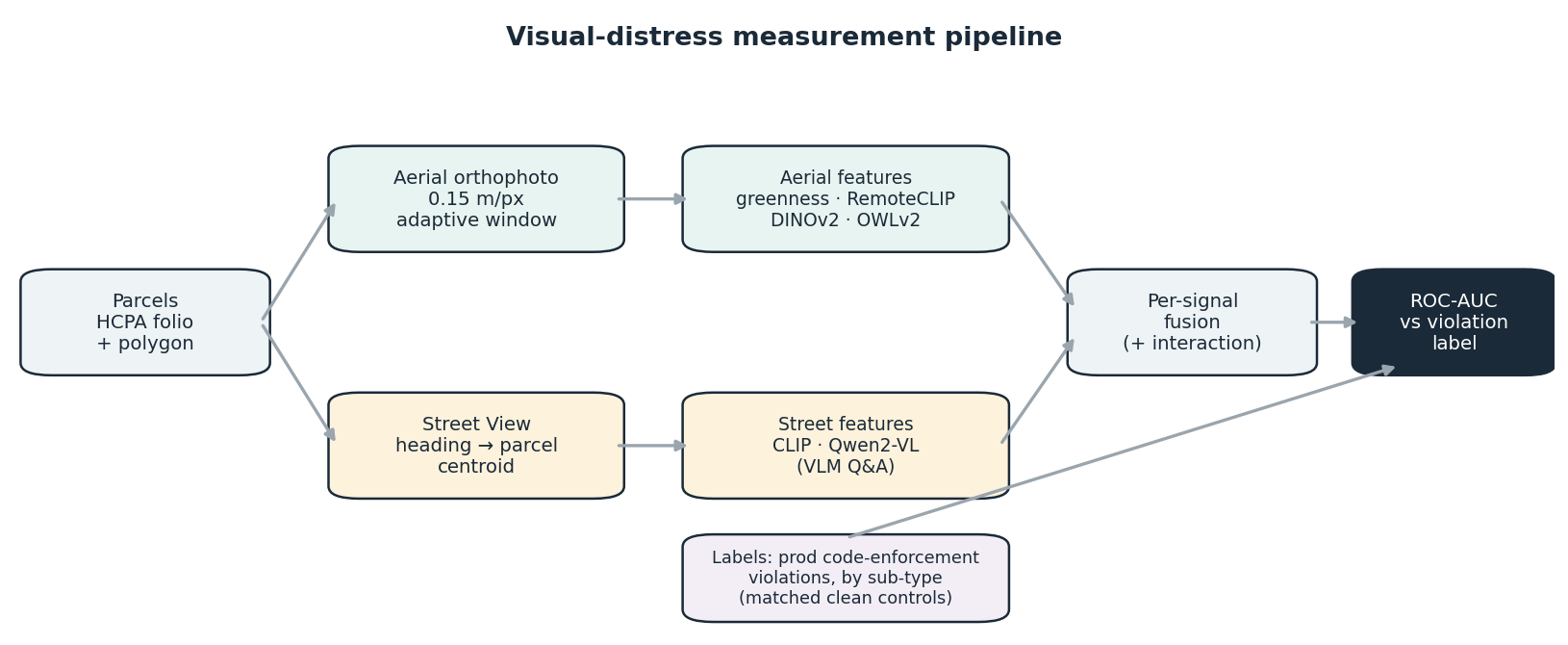
The study also runs counter to the assumption that bigger AI models win. A four-number measure of greenness out-predicted 768-dimensional foundation-model embeddings on the one signal aerial imagery can see, and a small 2-billion-parameter vision model matched a larger one. “The gains came from matching the question to the camera angle and combining views,” the paper reports. Model scale and power were not the key factors.
A third result speaks to where this could be used. A street-level detector that saw no local training data transferred to a second, independent metro (Broward County) without retraining. Because imagery covers nearly every U.S. parcel while digital code-enforcement records do not, a detector that works without local labels is one that coinuld stand in where the public record does not exist at all.
The study is deliberately conservative. It compares each violating property against a non-violating neighbor about 90 meters away, the hardest version of the test, and finds predictive accuracy plateaus in a modest range (ROC-AUC of roughly 0.6 to 0.7). The authors attribute that ceiling to the noise in code-enforcement records (complaint-driven and uneven) rather than to the imagery. The work is a preprint at SocArXiv 10.31235/osf.io/4u83q_v1
“Public records tell you what a jurisdiction has already written down. Public imagery can show the physical condition that made the record likely in the first place: sometimes a year earlier.”
DirtSignal has released an anonymized benchmark dataset and reproducible code alongside the paper, archived on Zenodo (DOI: 10.5281/zenodo.20672748), so other researchers can build on the work.
DirtSignal’s core product organizes code-enforcement cases, lien signals, clerk filings, hearings, demolition records, and related public records into ranked lead feeds, dashboards, weekly briefs, and exports for real estate acquisition and research teams. The company also offers custom property-risk studies for regions outside its standard coverage.
More information: dirtsignal.com
erik Aronesty
DirtSignal
press@dirtsignal.com
Legal Disclaimer:
EIN Presswire provides this news content “as is” without warranty of any kind. We do not accept any responsibility or liability
for the accuracy, content, images, videos, licenses, completeness, legality, or reliability of the information contained in this
article. If you have any complaints or copyright issues related to this article, kindly contact the author above.
![]()
Media gallery